10 years later, see how Superstorm Sandy changed the Northeast

Elevated beach homes, walls of sand dunes, and new urban parks show how New York and New Jersey have rebuilt after one of the costliest weather disasters in U.S. history.

Water, wind, and fire devastated the coastal community of Breezy Point, New York, after Superstorm Sandy toppled electrical lines and sparked fires that destroyed more than 100 homes—but left a statue of the Virgin Mary intact.
Photograph by Orjan F. Ellingvag, Corbis/ Getty Images
BySarah Gibbens
Photographs byGreg Kahn
October 20, 2022
12 min read
The Madonna Statue now sits on a stone plaque commemorating all those who helped the coastal community rebuild.
Relocated to a new home at St. Edmund Church, the statue of the Virgin Mary stands as a symbol of resilience. Words on the statue's base pay tribute to all those who have helped Breezy Point rebuild.
Photograph by Greg Kahn, National Geographic

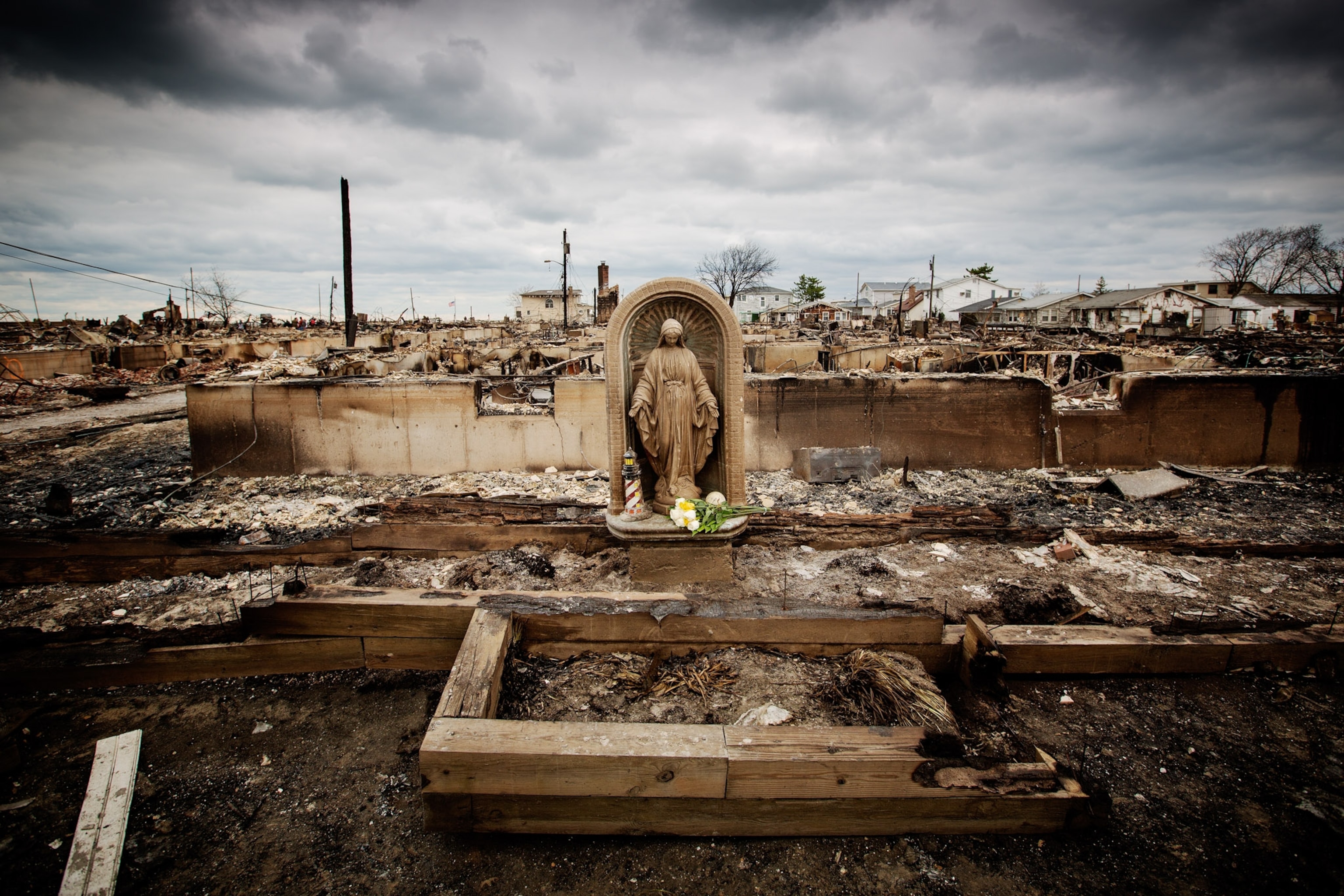
When Superstorm Sandy made landfall near Atlantic City, New Jersey, on October 29, 2012, it was unlike anything residents in the storm’s path had ever seen.

After a weeklong journey up the East Coast, Sandy was no longer technically a hurricane, but it collided with a powerful winter storm and created a behemoth “super storm” that pummeled coastal areas with 80-mile-an-hour winds and a storm surge as high as 14 feet.

The storm killed over 100 people in the U.S., destroyed 600,000 homes, and knocked out power to eight million residents. It was the fourth costliest storm of its kind in U.S. history, with damages totaling $81 billion, and it showed how vulnerable the region was to natural disasters.

Waves break in front of a destroyed amusement park wrecked by Hurricane Sandy on October 31, 2012 in Seaside Heights, New Jersey.
An amusement park at Casino Pier in Seaside Heights, New Jersey, was a stark display of Sandy's destructive power on October 31, 2012, two days after the storm made landfall. The normally vibrant resort town was made famous after frequently appearing on the hit reality show “Jersey Shore.”
Photograph by Mario Tama, Getty Images
The Pier at Seaside Heights, NJ
To make the amusement park better able to withstand future storms, the pier was shortened so that it now sits mostly on the beach. The Jet Star rollercoaster, wrecked by Sandy, has been replaced by a new rollercoaster called Hydrus.
Photograph by Greg Kahn, National Geographic
As Sandy moved inland on October 29, the storm surge reached as high as 14 feet in some neighborhoods. Under the Manhattan Bridge in Brooklyn, ocean water flooded a city street running along the East River.
Photograph by Bebeto Matthews, AP Photo
The Manhattan Bridge seen from John Street Park in Brooklyn, NY on Sept. 29, 2022.
Part of the land under the Manhattan Bridge has been converted to a park and walkway. Such green spaces help absorb floodwaters and reduce urban heat, making them popular solutions for cities adapting to climate change.
Photograph by Greg Kahn, National Geographic

“When Sandy hit, New York City had zero coastal protections, says Daniel Zarrilli, special advisor for climate and sustainability at Columbia University. “For a city with 520 miles of coastline, it’s almost shocking we didn’t have those interventions in the past.”

The destruction left by Sandy was a wake-up call. It pushed residents, city planners, and politicians to protect the coast from present threats and those expected in the future as a result of climate change.

Warming temperatures are making hurricanes stronger, rainier, and more likely to strike farther north. And as seas rise—seas along the coast of New York have risen nine inches since 1950—coastal flooding is becoming deadlier.

Planners knew they couldn’t rebuild the same structures the same way. They would have to be smarter, tougher, and higher off the ground.

In Tuckerton, New Jersey, homes built on a finger of land were swamped by floodwaters, as was the neighboring marsh. The storm highlighted the importance of wetlands, which absorb water surging toward coastal areas.
Photograph by U.S. Coast Guard, Getty Images
Homes on a Tuckerton, NJ
Many Tuckerton homeowners chose to rebuild, often several feet off the ground. Others opted to take government-funded buyouts and relocate.
Photograph by Greg Kahn, National Geographic
Floodwaters cascade over the construction site of the 9/11 Freedom Tower memorial on October 29, 2012. Lower Manhattan was especially vulnerable to flooding from the storm.
John Minchillo, AP Photo
The fenced off space where 5 World Trade Center will be built in Manhattan, is still yet to be started.
Today, many buildings in lower Manhattan have been fortified with retractable sea walls that can be erected when major storms threaten. To protect the lower half of the city on a larger scale, networks of levees and parks have been proposed to create a buffer between the ocean and dry land. The East Side Coastal Resiliency project, estimated to cost $1.45 billion, broke ground in 2020 and will protected an estimated 110,000 New Yorkers.
Photograph by Greg Kahn, National Geographic
Kathey Lahey sifts through debris of her home, which burned down in the fire the leveled much of Breezy Point, Queens, during the hurricane.
Six days after the storm hit her Breezy Point neighborhood, Kathy Lahey sifts through the wreckage of her destroyed home searching for photos of her daughters’ birthday parties. Lahey says she found a few charred photos, but everything else was lost.
Photograph by Allison Joyce, Getty Images
Portrait of Kathy Lahey, a former Breezy Point resident.
Lahey decided to sell her property in Breezy Point and relocate to Miami, Florida, for work. Devastating storms leave residents with challenging questions about whether to stay or rebuild. For many, moving means leaving relatives, neighbors, and the site of many memories.
Photograph by Greg Kahn, National Geographic

“I credit Sandy as that pivotal moment that not only launched billions of dollars of resilience investments across the city,” says Zarrilli. “It also provided the spark for a whole range of other climate policies.”

Ten years later, results of those policy changes are visible. New building codes have lifted beach homes several feet. Dunes on the Rockaway Boardwalk and an oyster reef off the coast of Staten Island stand ready to blunt the force of storm surge. In the Oakwood Beach neighborhood, government-funded buyouts have emptied a housing development that’s now becoming a wetland, returning to nature what couldn’t be protected.

Yet many reconstruction projects remain unfinished. Plans to create a buffer of parks around lower Manhattan have been stalled by controversy. And at Red Hook West in Brooklyn, the second largest public housing complex in the city, construction is still a very visible, audible, and unwelcome reminder of Sandy.

“There was sand all over the streets. I never saw so much sand,” says Coney Island resident Wilhelmina Fordham. Just days after the storm struck, volunteers worked together to clear sand blown from the beaches.
Photograph by Thomas Hoepker, Magnum Photos
The Coney Island boardwalk in front of Nathan's Hot Dogs in Coney Island, NY on Sept. 29, 2022.
Life has returned to normal along the Coney Island boardwalk. To fortify beaches against future storms, environmental groups in New York and New Jersey have replenished them with sand, built dunes, and planted beach grasses that help prevent erosion.
Photograph by Greg Kahn, National Geographic
People walk through the heavily damaged Rockaway neighborhood, in Queens on November 2, 2012
In Queens, the Rockaway neighborhood’s famous five-mile boardwalk was reduced to piles of splintered wood. The original boardwalk was built in 1931; its replacement opened in 2017. Today’s boardwalk is made of concrete and protected by retaining walls and dunes.
Photograph by Spencer Platt, Getty Images
Debris-free Shore Front Parkway at Rockaway Beach in Queens on Sept. 29, 2022
Today, Shore Front Parkway separates Rockaway Beach from residential neighborhoods. Earlier this year, the New York City Parks Department and local government unveiled a new playground and pickleball courts constructed along the parkway, touting them as a comeback from both Sandy and the pandemic. 
Photograph by Greg Kahn, National Geographic
Coney Island Subway Yard in Brooklyn, N.Y on October 29, 2012.
Sandy flooded the Coney Island Subway Yard about a mile from the coast, as well as ten subway tunnels connecting Manhattan to Brooklyn and Queens. Floodwaters inflicted some of the worst damage the century-old transit system has ever suffered.
Photograph by Lenny Pridatko
Coney Island Yard in Coney Island, NY
New York’s Metropolitan Transportation Authority (MTA) received $8 billion in federally funded programs to make repairs after Sandy. MTA plans to construct flood walls around the Coney Island subway yards, but the project has been stalled.
Photograph by Greg Kahn, National Geographic

“I can’t believe it’s 10 years already,” says Karen Blondel, president of the Red Hook West tenant association. “You go outside and there are double parked vehicles, trucks delivering materials. It’s chaos.”

Blondel says she and other residents have put up with years of construction so loud “you couldn’t talk or be on the phone.” But they’re hopeful that if they’re struck by a future storm, their buildings won’t flood and lose power for a month, as happened during Sandy.

“Most people,” Blondel says, “have been extremely tolerant because of hope that in the end they can stay in beautiful Red Hook.”

Large dunes are sheared off in Bay Head.
The beach at Bay Head, New Jersey, was recently replenished and fortified with dunes, but in early October remnants of Hurricane Ian swept away much of the sand. “Within a year, the problem is back again,” says resident Patti Durkin.
Photograph by Greg Kahn, National Geographic
Massive cleanup and relief efforts continue in the Rockaways, Queens following the destruction caused by Hurricane Sandy on November 8, 2012.
New York’s Rockaways neighborhood faced some of Sandy’s worst wrath. Many beachfront homes were damaged beyond repair, and massive cleanup and disaster relief continued for years. 
Photograph by Allan Tannenbaum, Polaris
Joanna Ostrander now lives in her mother's house that was completely demolished by Hurricane Sandy.
Rising to the challenge of climate change, this new beach house was built with the main living area on the third floor to provide an ocean view over proposed taller dunes. 
Photograph by Greg Kahn, National Geographic
A restaurant in New York's South Street Seaport is cleaned out, Monday, Nov. 12, 2012
Over a week after the storm hit, more than 75,000 people were still without power—and workers at a restaurant in South Street Seaport, a historic district on the East River, were still clearing debris and making repairs.
Photograph by Richard Drew, AP Photo
Sunday in Brooklyn pop up restaurant, a popular brunch spot in the South Street Seaport in Manhattan, N.Y. on Oct. 15, 2022
Diners fill a popular brunch spot in the transformed South Street Seaport district. The neighborhood’s Pier 17, once a struggling shopping mall that catered to tourists, was redesigned after the storm. It now hosts high-end restaurants, public spaces overlooking the river, and a popular concert venue on its roof.
Photograph by Greg Kahn, National Geographic
Emily Johnson of Catalyst Dance performs a dance in defense of trees. The East Side Coastal Resiliency project entails removing about 1,000 trees, and many residents oppose their removal.
Photograph by Greg Kahn, National Geographic
Clean-up continues amongst piles of debris where a large section of the iconic boardwalk was washed away on November 10, 201
Seen from the roof of a nearby building 12 days after the storm, a long stretch of Rockaway’s famous boardwalk is gone, swept away by Sandy.
Photograph by Spencer Platt, Getty Images
A look down Shore Front Parkway in Rockaway, Queens.
Years of work and millions of dollars have restored Rockaway’s beach and recreation areas. In addition to rebuilding the new boardwalk with concrete, the Army Corps of Engineers reinforced dunes and stone groins—long barriers extending from the beach to trap sand and reduce beach erosion.
Photograph by Greg Kahn, National Geographic
Kids throw a football on a newly constructed field at Pier 42 on the Lower East Side of Manhattan. The Pier 42 Upland Park and Pier projects will turn eight acres of industrial lots into playgrounds, bike paths, soccer fields, and tennis courts.
Photograph by Greg Kahn, National Geographic
Greg Kahn is a documentary and portrait photographer who concentrates on environmental issues that shape personal and cultural identity. Follow him on Instagram.

LIMITED TIME OFFER

Discover More, Spend Less
With new subscriber-exclusive stories published daily and complete archive access, your opportunities to explore are endless!