Lava built this island—then entombed towns in stone
After one of the Canary Islands' worst volcanic eruptions in centuries, a community confronts the damage, and rethinks its way of life.
The air ahead shimmers with heat as I approach an entrance to the underworld. Wind roaring in my ears, I carefully follow the footprints of my guide, Octavio Fernández Lorenzo, across a blackened landscape on La Palma in the Spanish Canary Islands.
“This is almost as far as we can go,” he says suddenly, stopping a few yards from our target, the maw of a volcanic cave known as a lava tube. We continue a few more steps toward the entrance, where a private drone operator had recently registered temperatures of 338°F—hot enough to bake bread. Fernández Lorenzo, vice president of the Canary Federation of Speleology, has been keeping close watch on the slowly cooling cave; he hopes to eventually enter to gather clues about one of the archipelago’s most destructive volcanic eruptions in 500 years.
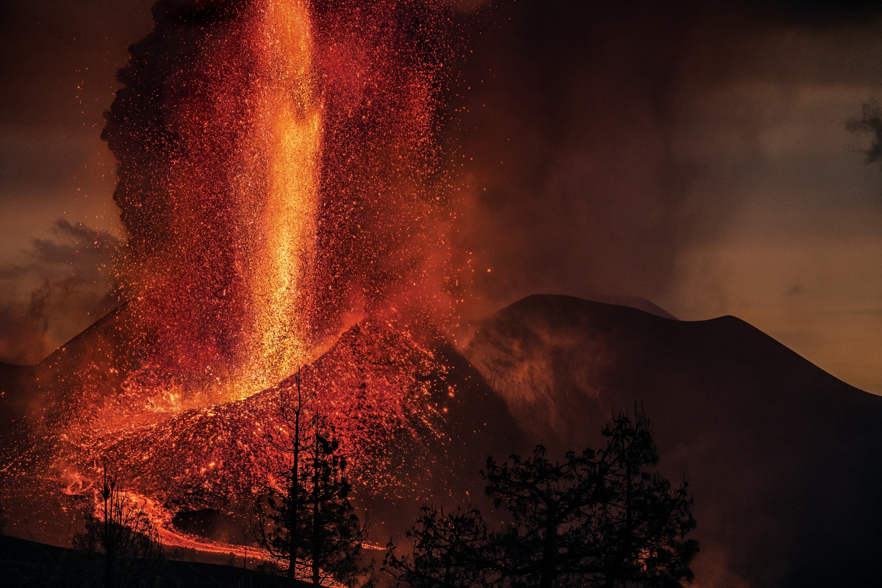
For nearly 86 days, starting September 19, 2021, molten rock coursed from cracks high on the island’s Cumbre Vieja ridge, inching downslope in incandescent rivulets that branched and rejoined like the strands of a braided stream. The volcano did not directly claim any lives. But the eruption gushed more than 261 million cubic yards of lava and built a cone of ash and rock over 650 feet tall, where we now stand. Just a year ago, this area of the island was a verdant pine forest with a scattering of homes. Now only the tallest parts—the upper branches of trees, the tip of a lamppost, the ridge of a roof—are visible above mounds of coarse black sand. Entranced by this dystopian scene, I barely register Fernández Lorenzo’s suggestion that we head uphill, his voice muffled behind a gas mask. But then his tone changes.

“Up, up, up, up,” he says, each word increasing in volume and urgency. “We’re going to burn.”
The wind had shifted in a gust from the valley below, potentially blasting us with scorching air. The ground crumbles and shifts beneath my feet as I struggle up the steep flank of the volcanic cone to find a safer perch for surveying the scene.
La Palma has a long history of eruptions, but its fiery fits usually aren’t considered dangerous. The chemistry of its lava makes it flow as sluggish rivers rather than explode in the dramatic blasts that devastate other parts of the world. The last eruption on the island was in 1971, when molten rock burst from a fissure in a sparsely populated region near the southern coast, providing a show of geologic pyrotechnics that caused comparatively little damage. Since then, though, the island’s population has grown; over 86,000 people now live on 273 square miles of land. When the volcano erupted last year, lava swallowed more than 2,800 buildings, 864 acres of farmland, and over 43 miles of road. Many difficult years of reconstruction lie ahead, hampered by lingering magmatic heat and an unclear economic future.


Around the world, about 60 million people live in the shadow of active volcanoes, so as the global population continues to grow, disasters like that seen in La Palma will become more common. Perhaps by better understanding what happened on this tiny island, its residents and those in similar communities can better prepare for future volcanic catastrophe.
“Volcanoes have built La Palma,” says Fernández Lorenzo. “We have to learn to live with them.”
Destructive as they may be, volcanoes are the lifeblood of the Canary Islands, a subtropical archipelago some 50 miles off the coast of Africa. Past eruptions sculpted the land into a spectacle of nature, from sweeping coastal cliffs and black-sand beaches to mountains packed with plants not found anywhere else.
Over the centuries, nutrient-rich lava flows have broken down into fertile soil. When Castilians conquered the islands in the 15th century, they ravaged the Indigenous population and converted the land into sugar plantations, which then gave way to other crops. Before the 2021 eruption, half of La Palma’s gross domestic product came from bananas grown for export.
Exactly what drives the Canaries’ volcanism is still debated, but much of the firepower likely comes from a plume of superheated rock rising from deep underground, known as a hot spot. As the African tectonic plate inches over this plume, new volcanoes—and baby islands—are born. La Palma is one of the youngest and most volcanically active islands in the Canaries. The northern volcanoes have fallen silent, though, and for the past 150,000 years, La Palma’s eruptions have struck exclusively in the hot, dry south, which is bisected by the Cumbre Vieja ridge.
Magma rises like a curtain under Cumbre Vieja, exploiting cracks or weaknesses to rush to the surface. No two eruptions follow the same path, a process known as monogenetic volcanism, which means scientists never know exactly where the next one will pop up.
As the recent eruption showed, this is a huge challenge for protecting the thousands of people who live on the slopes of the ridge. And after five decades of volcanic slumber, many locals had never witnessed their island’s full geologic power. There also seems to have been a disconnect between the activity scientists observed at the volcano in the days leading up to the eruption and what the public understood would happen. The result was devastating.
“We didn’t know what was coming,” says Ana Jesica Acosta Cruz, a local shop owner and previous resident of Todoque, a town now entirely paved over in jet-black rock. “We didn’t know it was going to be this demon.”

The earthquake swarm that kicked up on September 11, 2021, was one clue to the potential for disaster. The ground also began to swell and shift—a sign of magma moving below. Authorities quickly activated the islands’ volcanic emergency plan, which brought together a scientific committee of eight organizations and universities to pore over data and figure out what might happen next.
The plan communicates increasing volcanic hazards using a four-color “traffic light”—green, yellow, orange, and red. On September 13, authorities set the level to yellow, which means that the public should pay attention to official communications because of an increased eruption risk.
The earthquakes, which numbered in the thousands, migrated northwest as they grew ever more shallow and intense. “On Thursday [September 16], we all were almost sure that there would be an eruption,” says Stavros Meletlidis, a volcanologist at the Spanish National Geographic Institute (IGN), the official body responsible for volcanic monitoring throughout the country.
The big question was when. A 2011 eruption on the neighboring island of El Hierro was preceded by months of earthquakes. Yet the situation in La Palma seemed to be progressing more rapidly. Still, the scientific committee couldn’t reach a consensus that a blast was imminent, IGN’s director, María José Blanco, said in later testimony to the regional parliament. Such a declaration would have required politicians to change the volcanic alert level to orange, kicking off evacuations. But those are complex and costly, and timing is everything: Ask people to leave too soon, they may return to their homes before the threat has lapsed. If they leave and nothing happens, they may not trust future warnings.
On the morning of September 19, authorities began evacuating several dozen people with reduced mobility, saying they were worried about damage from the earthquakes.
Then the volcano erupted. The alert level still sat at yellow.
On a warm June day nine months later, I meet up with Sharon Backhouse, director of GeoTenerife, a U.K. company that has organized educational trips around the Canaries for nearly a decade. When she saw the disaster in progress on La Palma, she stayed to document the eruption and recovery efforts through local residents’ eyes in a project now known as #VolcanoStories.
Sounds of generators and jackhammers greet us as we approach the remains of a school, La Laguna’s Early Childhood and Primary Education Center. Its director, Mónica Viña, peers through a chain-link fence surrounding the property, now dwarfed by a wall of lava rock nearby. As Backhouse translates, Viña shows pictures on her phone and describes what the school used to look like. About 150 students ages three to 12 once gathered in this trio of flat-topped concrete buildings painted brilliant blue trimmed in white.
At first the lava flow bypassed the school, and Viña hoped the complex would be spared. But luck ran out on October 20. Viña pauses, fighting back tears. “We always thought it wouldn’t happen,” she says, her voice barely audible above the din of construction. “It’s very sad to see it like this.”

Just one building still stands. The fan of an air conditioner droops on its spindle as if it were made of putty. A lamppost is split down one side. We pass a hefty tree toppled on its side, its roots in a death grip around chunks of concrete ripped from the ground. For Viña, the chaos is a potent reminder of the value of education, especially when it comes to understanding local hazards.
“We knew what a lava flow was, but we didn’t know the impact it could have on the population,” Viña says. She plans to start bringing scientists into the school to talk with students about volcanic blasts. They should learn about the dangers, she says, “even if nothing happens.”
Almost a year later, many of La Palma’s families remain in temporary housing, waiting for promised funds from the Spanish government and decisions about how to rebuild. Some are struggling to prove ownership of their land after leaving behind legal documents in the rush to evacuate. Then there’s the debate over how to rebuild on such a dramatically altered landscape. Lava consumed entire neighborhoods, leaving the land—and the lives of those who called it home—forever changed.
Some parts of the new lava flow will likely be preserved as a national park, to be a poignant reminder of the island’s volcanic underpinnings. Other parts will be reclaimed by agriculture and buildings as soon as the deep rock fully cools. But the challenges are steep. Much of the flow is what residents call malpais, or “bad land,” because it’s full of jagged rubble that shifts underfoot and can cut clothes and skin.
The eruption also landed a heavy blow to island agriculture, particularly the banana-growing industry, which is heavily subsidized by the Spanish government. The natural process that transforms fresh lava rock into fertile soil takes hundreds of years, and farming on top of the lava flow would require moving soil in from elsewhere on the island.
In addition, bananas need lots of water to grow. A series of pipes currently transports water from the island’s wet north to the patchwork of banana terraces across the hot, dry south. But with water at a premium and many plantations now buried under rock and ash, some people are questioning whether bananas are truly the best fit for La Palma.


One such argument comes from Victoria Torres Pecis, the owner of La Palma’s oldest operating winery. Like her parents and grandparents before her, she’s spent her life caring for small plots of grapevines tucked across the island. Dried leaves cover the bottom of her van when I join her on a sunny afternoon to visit some of her vineyards in Fuencaliente, near La Palma’s southern tip. As we bump along the dirt road, she talks passionately about her efforts to work with the volcanic lands in their most natural form.


“We think we can change everything,” Torres Pecis says of efforts required to grow water-hungry crops. “We haven’t been paying enough attention to where we live.”
She slows the van, pointing to some of her plots. The plants look almost wild, nestled into steep slopes of black ash. The roots dig deep under the surface to tap into the more evolved, clay-rich soils. Unlike the banana farmers, she doesn’t irrigate, relying instead on natural rainfall and the sea of clouds that glides up the island’s steep slopes. The top layer of ash holds moisture from the air and retains heat that ripens the fruit. Only recently has an extended drought forced some vineyards to selectively water to make up for the loss of rainfall.
Torres Pecis has found that embracing the island’s complicated terrain can bear unexpected beauty: You can taste the difficulties the vines face. She offers me wine from three barrels made from the same variety of grapes. The first comes from vines grown in older, nutrient-rich soils in the wet northern regions, which produce a slightly sweet, simple taste. But the other two wines are made from grapes grown in the south’s more challenging conditions—in younger, drier soils or on windy slopes—which create surprising complexity and depth.
Winemaking isn’t an easy profession, and Torres Pecis acknowledges that bananas are an important part of La Palma’s history. But she argues that the island’s agricultural future should lie in a variety of crops better suited to the dry climes, such as figs or sweet potatoes. If there’s a positive from this event, she says, it’s that the eruption opened many people’s eyes to the forces that gave rise to La Palma’s picturesque cliffs and undulating land.
“You start to see volcanoes where you saw a mountain before,” Torres Pecis says.


Despite the tragedy, many residents seem to have only strengthened their devotion to their home island. They proudly wear La Palma–shaped pendants and beaded bracelets colored in the yellow and blue of the Canary flag even as they embark on the difficult tasks of rebuilding. And rethinking agriculture is just one lesson being considered in the wake of the latest volcanic outburst.
Debate has also brewed over the volcanic traffic light that’s used to alert the community of potential hazards. After the 2011 eruption on El Hierro, authorities added an “orange” level to provide more nuance to warnings when an eruption seemed imminent. But in the hours leading up to La Palma’s recent blast, the orange alert wasn’t used, sowing confusion.
One possible explanation lies in the current emergency plan’s inflexibility, says Jose M. Marrero, an expert in volcanic hazard and risk assessment at Montserrat Volcano Observatory. Because the system directly links the alert levels to required emergency responses, certain scientific observations about volcanic activity trigger a domino effect ending in major steps, such as wide-scale evacuations. As a result, the onus of major policy decisions essentially rests on scientists alone, which could affect how they interpret the data, whether subconscious or not.
These lessons reach far beyond La Palma’s shores. But the urgency of finding solutions to the challenges is at its clearest in the Canary Islands.
Sitting at the Volcano Cafe in Santa Cruz, the bustling capital of nearby Tenerife island, volcanologist Meletlidis and I talk of the many challenges of living with slumbering volcanoes. As a constant stream of people and cars passes by, I wonder aloud about concerns for a future eruption here, the Canaries’ most populous island.
Meletlidis’s response is immediate, his voice low: “We think about it every day.”
A version of this story appears in the November 2022 issue of National Geographic magazine.


